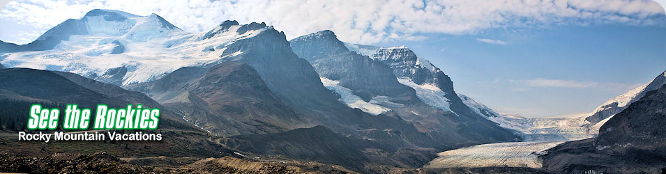
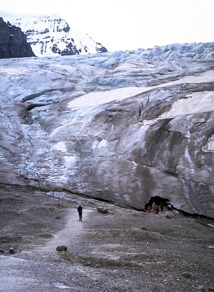
The Columbia Icefields, partially situated in Banff National Park and partly within the boundaries of Jasper National Park, is the largest amount of ice accumulation in the Canadian Rockies and is the largest south of the Arctic Circle. These icefields cover an area of more than 300 square kilometres (186 miles) and are over 350 metres (1000 feet) thick. Conditions here are almost the same as during the last ice age that occurred between 75,000 years to 100,000 years ago. The glaciers that form the Columbia Icefields feed four of Canada’s major rivers: The Columbia, Fraser, Mackenzie and Saskatchewan that flow into different directions and oceans.
 Aboriginals knew about the Columbia Icefields and their location, but Europeans did not see them until 1892 and then only from the peaks to the east. The first close up sighting was in 1898. Today, because of the Icefields Parkway, the Columbia Icefields are very accessible and seen by millions every year. The first trip along what is today’s Icefields Parkway was in made1904, but it was 1931 before road construction was started. Crews worked from both north and south towards a meeting spot just south of the Columbia Icefields. The finished product was a 230-km (140-mi.) gravelled road that made its way through landscape that was like no other in Canada. In 1961 the Parkway was resurfaced, keeping most of the original road. Services along this corridor are far and few between, especially in winter, when its advised that travellers carry survival equipment, food, water and extra gasoline.
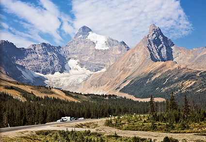
 The Icefields Parkway (Highway # 93) that connects Lake Louise in the south to Jasper in the north is known as one of the world’s most spectacular mountain highways, and for good reason. Scenery in this part of the world is breath taking. Travelling from the south to the north you make your way through five different valleys, they include the Bow, Mistaya, North Saskatchewan, Sunwapta and Athabasca. Each valley and every mountain is different.
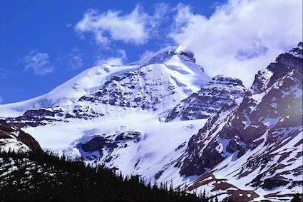
Starting at Lake Louise, heading north you climb through forests to the Bow Summit, the highest point on the Parkway. By the time you reach the alpine meadows of this section you have travelled by the Crowfoot Glacier, Bow and Peyto Lakes. From the Bow summit to Saskatchewan Crossing you wind your way alongside the Mistaya River to the valley of the Saskatchewan River. Watch for moose and black bears along this section. The next section of highway takes you from Saskatchewan Crossing to the Columbia Icefields that includes a steep climb. Scenery along here is spectacular. Once you leave the Columbia Icefields and Tangle Ridge the Parkway drops as you follow the Sunwapta and Athabasca Rivers in Jasper. Mountain goats, bighorn sheep and elk are often seen along the way.
Attractions:
The trip is approximately 230-km (140-mi.) and takes you through majestic mountain scenery. Paralleling the Great Divide, the Icefields Parkway takes you by the Columbia Icefields, both the Bow and Crowfoot Glaciers, beautiful Peyto Lake and the famous Athabasca Falls. Along the way, watch for moose, elk, caribou, black bears and grizzly bears.
 Activities:
Sightseeing is the larger drawing card to this region. There are hundreds of opportunities for photography and wildlife viewing. Walking, hiking, mountain biking, fishing and ice-tours are all very popular.
Icefields Parkway:
This highway links the Trans Canada (Highway # 1) Highway from Lake Louise to Jasper. It also links with the David Thompson Highway (Highway # 11) that heads east to Red Deer, Alberta. The junction is approximately an hour west of Banff, 3 hours west of Calgary and 4 hours west of Edmonton. The trip takes about five hours one way, but take your time, as there are many viewpoints, picnic areas and short hiking trails to explore.